
Welcome, this is the first post in a new blog I'm writing about transit and biking in the SF Bay Area. Since the year has just started (please ignore that we're just past 1/12th of the way through the year), I thought I'd start off with a post about things I'm excited about in the transit/bike world that are happening in 2024.
It's sometimes easy to feel down or cynical about biking & transit progress in SF, but this post will focus on the positives. We could always be doing a lot better, and we should look towards places like Paris or even Vancouver, BC for inspiration, but there are nonetheless a bunch of upcoming changes that are worth celebrating.
I'll start off with some bike infrastructure topics then talk about transit.
🚲 New quick build projects
Every year the SFMTA is building more quick build bike projects that improve whole corridors in the city. There've recently been some setbacks and controversies on some projects (cough Valencia cough) but I think overall the program has been doing an incredible amount of good with a limited amount of resources and it's important to highlight that.
Sloat Boulevard to Lake Merced to Stonestown
The quick build corridor for 2024 that I'm most excited about is the Sloat Boulevard project. Right now if you want to bike to Lake Merced or Stonestown from elsewhere on the west side of the city, the options are ok for experienced cyclists but aren't really great (definitely not "8 to 80" infrastructure). Getting to Lake Merced generally involves biking along Sloat and Skyline Boulevard, neither of which feel very safe at all with fast moving traffic.

Stonestown, on the other hand, is not too bad during the day along 20th Ave and through Stern Grove. At night, however, Stern Grove is pitch black and not fun to bike through.
With the quick-build project, there will be a new safer route to both of these locations from the north. First, the Sloat project itself will add two-way protected bike lanes that hug the south side of the street near the Zoo:
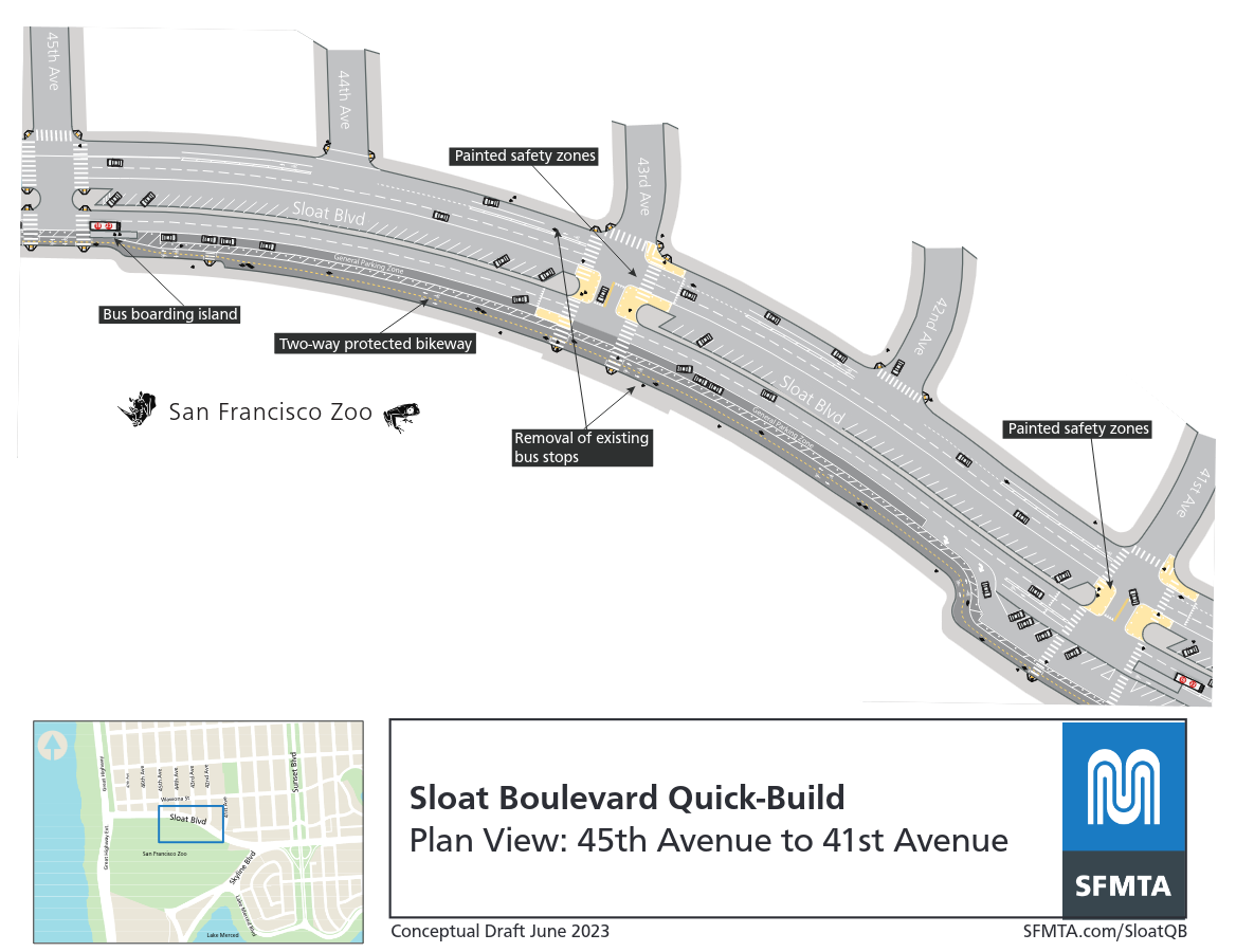
This plan view shows a location near the Streetview screenshot above. The new PBLs put people who are biking between away from traffic with a buffer of parked cars. This also reduces conflict points between drivers who are parking and people who are in the bike lane.
The new protected lanes will start near the Great Highway and extend to the Sloat/Skyline intersection. Overall I think it will be a huge improvement over the current infrastructure. The project was approved by the SFMTA board in July 2023, and it's projected to open sometime in 2024.
But it's not just this project that will make the route work. There is also a funding allocation already approved for new traffic signals at the end of the PBL near the Sloat and Skyline intersection. This is a notoriously bad intersection that's difficult to navigate for anyone walking or biking right now. While a few years ago, city agencies were brainstorming ways to radically change the intersection (a roundabout was in the cards), practical constraints have led to a near term plan to add signals and ramps.

Finally, all of this will connect to the Lake Merced Quick Build project that's already under construction. This project is already making biking more comfortable around Lake Merced. All of the projects linked together will make it possible to travel first along the Great Walkway/Bikeway (or the multi-use path next to it on weekdays), then along Sloat, across a signalized Sloat/Skyline, then finally along Lake Merced to Stonestown.
(Stonestown itself may become a biking/walking haven in the future, but that's for another post)
The point is, when all of this is done it will be a pretty significant addition for SF's west side in terms of bike infrastructure and form a connected network.
Oak Street Quick Build
Another exciting quick-build project is the Oak St project. This is a companion project to the COVID-era Fell St bike lane project that was already built and permanently legislated. While the Fell lanes are oriented towards the west side from downtown, the Oak lanes will allow for bike traffic to flow towards downtown.
While I'm excited by the project and in general and think it will be useful, I actually think the potential to connect the Panhandle to Golden Gate Park is the more interesting part rather than the bike lane on Oak itself. The SFMTA explicitly calls this out in one of their goals:
Improve connections to and from Golden Gate Park for people bicycling on JFK Drive, including modifications at the Kezar Drive and Stanyan Street intersections
The fact sheet for the project also suggests that there are some intersection changes coming:
Future intersection improvement project at JFK Drive & Kezar Drive to improve the safety of people bicycling eastbound on JFK Drive across the Kezar Drive intersection, including a new traffic signal (separate from quick-build project)
I'm guessing this would mean a traffic signal might be in the cards for this intersection that many bicycle riders from the west side are extremely familiar with:

That alone would be very positive, as this is not an easy crossing with the constant flow of traffic (even on a red at Kezar there are right-turning cars from Stanyan St) and people driving cars are sometimes confused about right of way.
If the city has more resources, I've wondered for years if the current buffer space (and the unused rightmost car lane that leads into the park) along JFK/Kezar and Fell could be repurposed to put in a two-way bike lane that connects the Panhandle to GGP. It would look something like this very sketchy diagram:
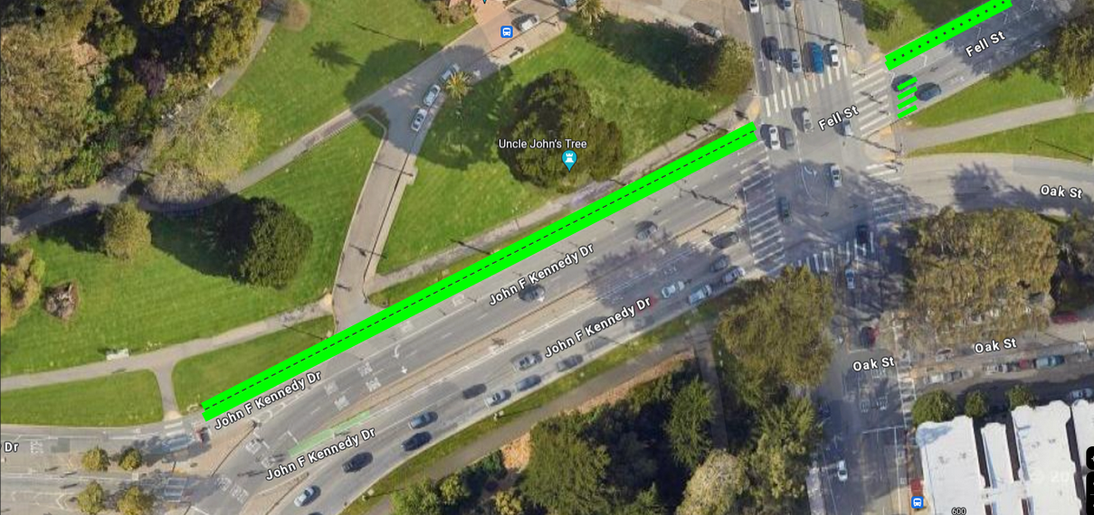
Maybe this is unworkable due to the complexity of the Fell St and Shrader St intersection, but I've always thought the existing buffer space seemed like a waste and that a two-way bike lane might make a good connection here that avoids the unsignalized Kezar crossing.
🚲 Bike network gap closures
In contrast to the future Sloat Boulevard corridor, many of the protected bike lane corridors that SF has built so far aren't very well connected together. Thankfully, the city is aware of some of these and have concrete fixes planned.
For example, there are pretty good bike lanes in both SOMA and also parts of the Mission Bay neighborhoods. Specifically, 2nd St has a protected bike lane that was finished in early 2021 and Townsend has pretty good bike lanes until the 4th and King Caltrain station as well.
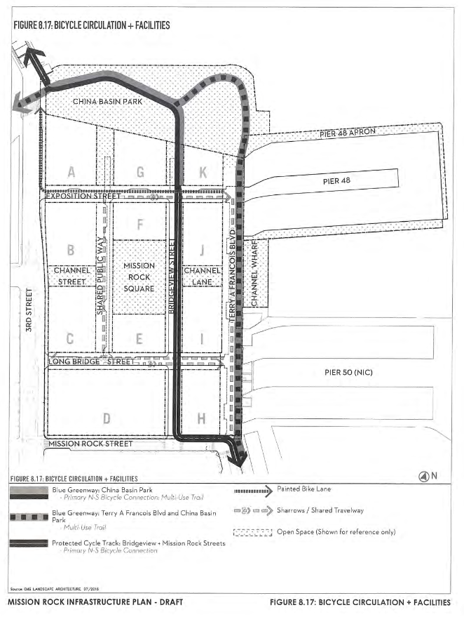
Mission Bay has new bike infrastructure next to the Chase Center that connects to 3rd St near Oracle Park. This is kind of a side point, but these bike lanes are also slated to get significantly better once the Mission Rock development opens. At that point, there would be two-way protected bike lanes on both Terry Francois Boulevard and the new Bridgeview Street as the following circulation diagram shows:
Unfortunately there's still a gap between 2nd St and the bike lane over the Lefty O'Doul Bridge that you can see clearly on a map:

There are just no bike lanes at all continuing on 3rd St to elsewhere in SOMA and the connection from 2nd St, while possible via the rear side of the ballpark, is not legible.
SFMTA's 3rd Street Quick Build project is covering just this gap. It would build a protected bike lane from the 3rd St Bridge to Townsend Street, as the proposed design shows:

This project is only two blocks long, but I think it's the kind of project that SF needs a lot more of because of the connectivity it offers. A future Townsend Quick Build project is also planned, which is scant on details but will hopefully extend the PBLs from around Caltrain to 2nd St and to the Embarcadero.
Another example of a gap closure fills a gap that has bugged me for many years. While Golden Gate Park nowadays has some great infrastructure, the connections from the park to the neighborhoods around it are sometimes not good. Along 7th Ave in the Sunset, there is actually a strong attempt at this with a bike cutout (modal filter) in the intersection:

This intersection design strongly suggests that this street would be a good path to get in and out of the park. Unfortunately, it doesn't work well at all currently because there is not even a unprotected class II bike lane on 7th Ave until three blocks later at Kirkham St. There is a planned project to fix this though (you can find it in the 5-year planning document for Prop L). It's technically not planned to open until 2025-26 so maybe I should've mentioned this in a future Jan 2025 post, but I imagine the design efforts will be kicked off this year.
There's also more hope for completing the bike network in SF because the city is putting together a new Bike Plan. There were some huge challenges with the previous bike plan, but I'm hoping this one will be ambitious and close many of the key gaps we have in our network. There's not a whole lot of info out about this yet, so I didn't dedicate much space to it.
🚆Transit in 2024
Transit in the Bay Area is definitely going through a challenging time, especially with regards to ridership recovery after COVID and the funding model for agencies like the SFMTA that rely on declining revenue sources. There are also huge problems with regards to planning and delivery processes for the region's transit projects.
Despite this, 2024 will also see some very impactful initiatives take off for Bay Area transit. I'm particularly excited about the following three topics.
Caltrain Electrification (CalMod)
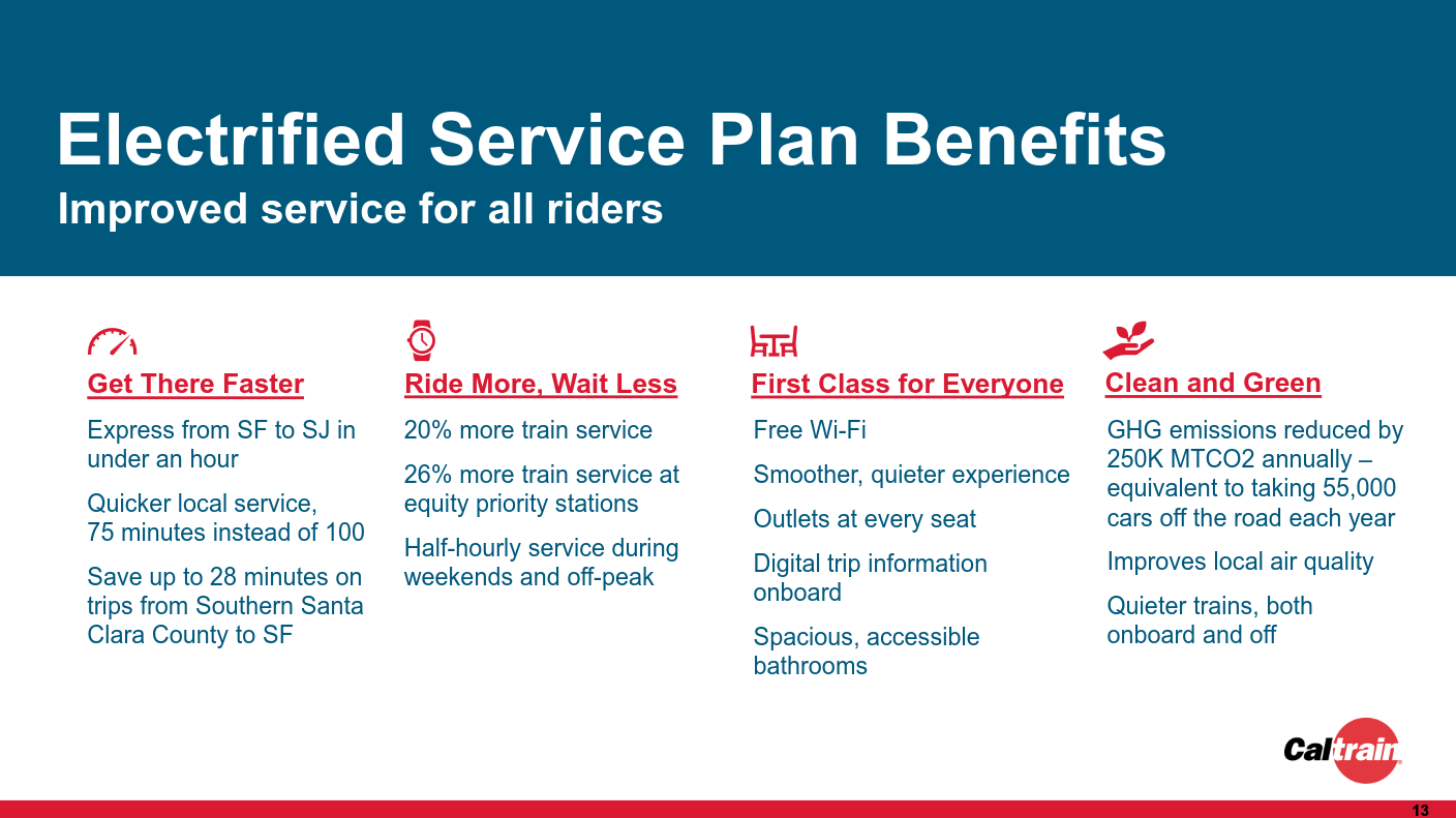
This is a huge one! Despite it not even making it into Yonah Freemark's excellent 2024 transit project openings blog post, this is one of the biggest advances in Bay Area transit in a long time. To explain the project very briefly, Caltrain Electrification (called CalMod in short) will replace the current diesel trains with modern electric trains from a European manufacturer (Stadler). This means less pollution, better train performance, and more comfortable rides. The new service with these electric trains is scheduled to begin sometime in Fall 2024 (September if there are no further delays).
On a near-term level, electrification enables Caltrain service to speed up significantly due to faster acceleration (SF to San Jose local service would speed up 25 min from ~100 min today to 75 min). Higher transit speed also frees up resources for better timetables, and electrification will also result in higher frequency of service (15 min frequency at many stations during peak, worst case 30 min during off peak and weekends).
Looking to the longer-term, CalMod is the first step towards establishing a modern electric intercity train network for the Bay Area and for California as a whole. The California High-Speed Rail project is planned to eventually link to the Bay Area by using the Caltrain tracks, which is only possible due to electrification.
More locally, Caltrain will eventually connect to The Portal (a project once known as the Downtown Extension, a name that doesn't make me go "huh?") which will make Caltrain function as a third subway service (after Muni and BART) for downtown SF. Though it's taken far too long, there is also an effort to plan a new station for Caltrain that serves the Bayview area (and could see frequent subway-like service due to electric trains). Especially if combined with fare integration, I think this would be an important step towards righting historical wrongs with regard to transit service to the Bayview.
A little further afield, the State Rail Plan and Link21 projects are also considering a link from The Portal that will cross over to the East Bay, linking up to regional train lines like the Capitol Corridor there.

In a few decades, we might look back and reflect that CalMod provided the basis for an extensive regional train system that knits together Northern California.
Clipper 2.0 and Seamless Transit
In late 2024, the long-awaited Clipper 2.0 update is coming for the region's inter-agency transit card system. There are a lot of details about how the system is "account-based" and so on that I don't think are actually very exciting, but these technical details do enable some major rider-facing changes that will be extremely worthwhile.
The first is very simple to explain. The Clipper 2.0 upgrade will enable contactless payment for transit fares. That means fares will be payable with whatever devices/cards you may already use to tap to pay for a coffee at a cafe or for groceries at a supermarket.
I think this will lower the barrier to ride for many people and will have a positive impact, especially for tourists. I've experienced this myself while visiting cities like Portland, Vancouver, and Sydney which all already offer contactless payment as an option.
The second benefit of the new Clipper system is that it will enable lower-cost transfers between transit operators. Currently, if you ride a Muni bus and then transfer to a BART train, you will have to pay the full fare of both Muni and the BART train. Similarly, you have to pay full fare twice if you transfer from one bus operator to another operator.
While people are used to this in the Bay Area, this is kind of weird actually! I can make unlimited transfers between Muni buses (within a certain time window) but if I make a single transfer to Samtrans, I have to pay more even if that multi-agency trip uses fewer resources overall.
The lower-cost transfer policy will utilize Clipper 2.0 to provide a $2.5 discount for transferring between operators. BART has a slide illustrating how this would work:
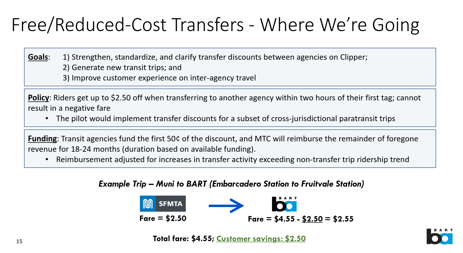
In their example, a person transferring from a Muni bus (say the 1 bus) to BART at Embarcadero Station who is bound for Fruitvale Station would pay a total of $4.55 under the new policy. The current fare for that trip is $7.05.
That is definitely nice, but I think the bus example is more compelling. A transfer from a Muni bus to a Samtrans bus will be a free transfer because the standard adult fare for Samtrans is $2.05, which is less than the $2.50 discount.
While more fare integration beyond this policy is absolutely necessary, this first step will likely help make the case for further reform.
I won't go into detail to avoid making this post too long, but there are other exciting regional initiatives to make transit more seamless, such as universal signage for the region, that are also kicking off in 2024.
ACA-1 in the November election
While the November election is obviously extremely important for a number of reasons, it could also have a huge impact on California's transit as well.
The state portion of the ballot in November will host a constitutional amendment called ACA-1 which will reform how the state can fund important infrastructure projects.
Right now the state maintains an anti-democratic system, passed unfortunately by previous ballot initiatives, in which raising funding (via taxes) for infrastructure projects requires a supermajority (66.7%) vote by the voters.
People living in SF may remember that in 2022 this requirement killed Proposition A, a bond measure that would have funded transit improvements in SF. This measure had 65% support, which is a huge amount but just under the 66.7% threshold. It's absurd that even though such a large majority of people living in SF wanted to improve our transit, it was possible for a minority of voters to sink it.
ACA-1 changes this by setting the threshold to 55% for funding infrastructure, which would have saved Proposition A and other similar funding measures. This is an extremely reasonable threshold that could only be met if a clear majority supports it, and ACA-1 also stipulates some accountability requirements as well.
This is definitely not as flashy as a new train service or lower fares, but it will probably be more impactful than those in the long-term. Right now California is in a situation in which we can't even build nice things even when the people want it, and this measure would allow us break a key piece of that logjam.
Looking forward to 2024
The topics I covered here are mostly projects or initiatives that will either fill a gap to make the whole network function better (such as bike network gaps) or are important building blocks that enable further improvements to the system (electrification for a future regional network, fare reform towards seamless transit, funding reform that leads to more and more transit). I see 2024 as an important year for building foundations that will let future residents of SF and the surrounding region have more fun biking and taking transit to where they need to go.